The O’Brien-Kelly Family from County Carlow, Ireland
Bob Gray
October 2017
Introduction
This document is really an update to my “Researching My Mother’s Irish Roots” page [1]. The original page made a lot of progress, but I made several mistakes at the conclusion of that page for the O’Brien-Kelly family in County Carlow, Ireland. As discussed in the July 2017 update to the original page, I ended up verifying that Anna E. O’Brien’s maiden name was Kelly. This information was verified by Anna’s death record, shown below. I am leaving the original page unchanged as a record of how I ended up with the information used as a starting point for this page, as well as, a reminder to not make the same mistakes again.
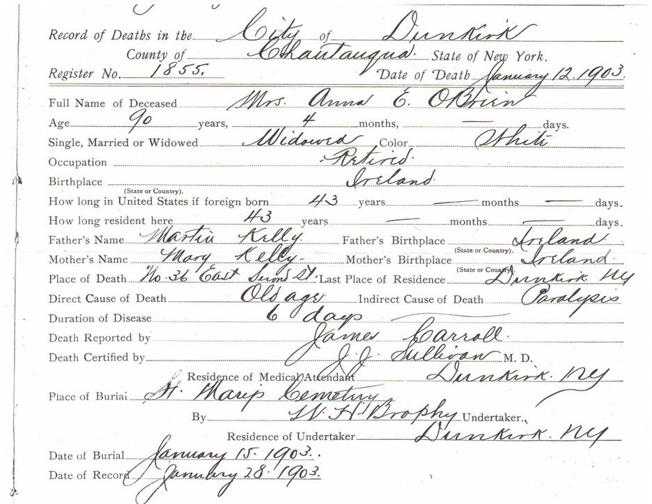
Anna E. Kelly O’Brien’s Death Certificate from the City Clerk of Dunkirk, New York which identifies her parents as Martin and Mary Kelly.
This first part of this page focuses on William Brien, including where the Briens lived in County Carlow, Ireland, possible fathers of William, and his occupation. Then, the results of a search for Anna E. Kelly O’Brien’s parents are presented. As discussed in Researching My Mother’s Irish Roots, there is a marker for a Michael McDonnell in the O’Brien plot at St. Mary’s Cemetery in Dunkirk, New York. Therefore, a search was made for Michael McDonnells in County Carlow where William and Anna Brien lived. Finally, available census and other records for County Carlow were searched for evidence of the families before and after the time William and Anna Brien lived in Ireland.
William Brien and Anna E. Kelly
William Brien and Anna E. Kelly were married on August 11, 1839 in Clonegal Parish, County Carlow, Ireland. Their marriage record, shown below, provides only their names, the place of the marriage, and their two sponsor’s names. Note, this is a modern transcript of the original parish records. Anna’s given name is spelled Anne in the record but there is little doubt that this is the correct marriage record as baptism records for their six children were also found in the records of the same parish.
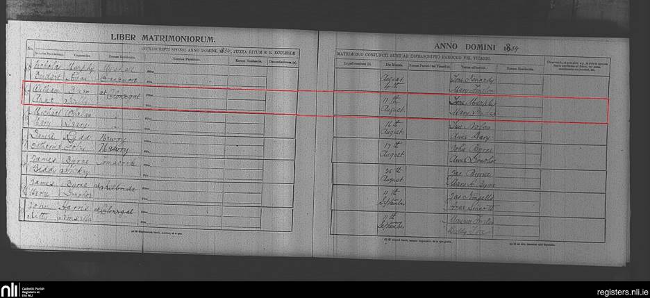
Modern transcript showing marriage of William Brien and Anne Kelly, August 11, 1831, Clonegal Parish, County Carlow, Ireland (Source: National Library of Ireland).
The biggest mistake I made in the original research was to assume that baptism records for William Brien and Anna E. Kelly would also exist. I later realized that Roman Catholic baptism records for Clonegal Parish only exist from 1831 on. Based on her obituary, Anna was born on September 8, 1812 which explains why no baptism record was found for her during my original research. While I didn’t force fit a baptism record for Anna, I did for her husband, William O’Brien.
The baptism records for William and Anna O’Brien’s children identify the family as living in Coolroe, a townland about three miles outside Clonegal proper. In an effort to obtain information on the family during the time prior to their immigration to the United States, I returned to the Griffith’s Valuation records. Griffith's Valuation (more formally The Primary Valuation of Tenements) was a systematic valuation of all property in Ireland. It was carried out between 1848 and 1864 and takes its popular name from Richard Griffith, the director of the valuation. In my previous research, I had found little value in the Griffith’s Valuation records as they only provide the name of the owner and/or occupant of a property. However, I found that the Ask About Ireland site [2] includes a link to maps and written material collected as part of the valuation. The site also provides guidance on how to interpret the information contained in the records, something I may have missed in my previous excursion into the records. Additionally, unless there is supporting evidence for a family living in a specific townland, the Griffith’s Valuations are too general to be of much aid from a genealogical standpoint. The information given in the valuation is:
· Townland name (street name in urban areas),
· Valuation map number,
· Local number,
· Householder's name,
· Landlord's name (under the heading 'immediate lessor'),
· A brief description of the property,
· The area of the property in units of acres, roods and perches, and
· The rateable value of the property.
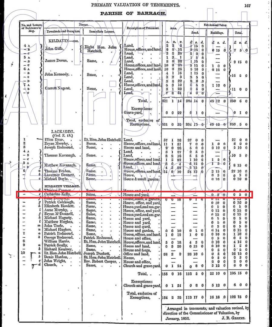
The valuation is arranged by county, barony, civil parish and townland. It is important to note that the civil parish name may be, and most likely is, different from the Roman Catholic Parish name. The O’Brien children’s baptism records were for the Roman Catholic Parish of Clonegal which is in the civil parish of Myacomb. According to Wikipedia, the Griffith’s Valuation of County Carlow was completed on 28 June 1853.
The Griffith’s Valuation page below is for the civil parish of Myacomb and it lists the townland of Coolroe. The useful information is contained in the first four columns of the table. The second column lists 20 people under the Coolroe townland and William Brien is the second entry. The second column is the householder’s name while the third column is the immediate lessor’s name. It is noted that Henry Bruen is the immediate lessor for most the dwellings in Coolroe. Henry Bruen is listed as the occupier just above William Brien, with the identification “In fee” for the immediate lessor which Ask About Ireland says means that the occupier is also the legal owner of the property and therefore, owned the property listing William Brien as the tenant. Further, the fourth column provides a description of the property and William Brien’s property is identified as a house, so we now have further evidence that he and his family lived in Coolroe.

Griffith’s Valuation table from Ask About Ireland listing the occupants of houses in Coolroe, County Carlow, Ireland. William Brien’s listing is outlined by the red box.
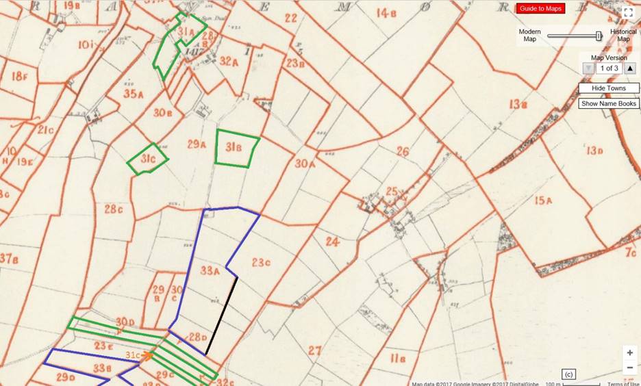
In the second column of the table above, it is noticed that under the townland name of Coolroe there is a notation of “(Ord. S 14 & 15).” This is a reference to a sheet of an ordnance survey map of County Carlow that accompanied the Griffith’s Valuation. Ask About Ireland provides a link from the on-line townland listing to copies of the map from the mid-1800s. The maps are somewhat detailed and difficult to navigate as the townlands are not keyed[i]. There are townland names listed on the map, so one must scroll around the general area until the proper town is found.
The map below shows Coolroe outlined in green. Note the name, Coolroe, is in grayscale along the middle of the map. The map shows Coolroe Townland is approximately 5.1 miles high and 4.3 miles wide. The horizontal line about one third of the way up from the bottom is the dividing line between sheets 14 and 15 which is identified in the Griffith’s Valuation table above. Attention is now called to the red lines inside the green border for Coolroe. These subsections are labeled 1 to 10 with two entries for 8 (8a and 8b). These numbers, including the 8a and 8b, are consistent with the numbers on the left side of column one of the Griffith’s Valuation table shown above. On the right side of the map reference column are letters. These correlate with the letters on the map below within each of the 11 subsections. Note that there is a b next to William Brien’s name in column one. It means his house is located at the b inside subsection one which is to the left of the red arrow on the bottom right side of subsection 1 in Coolroe.
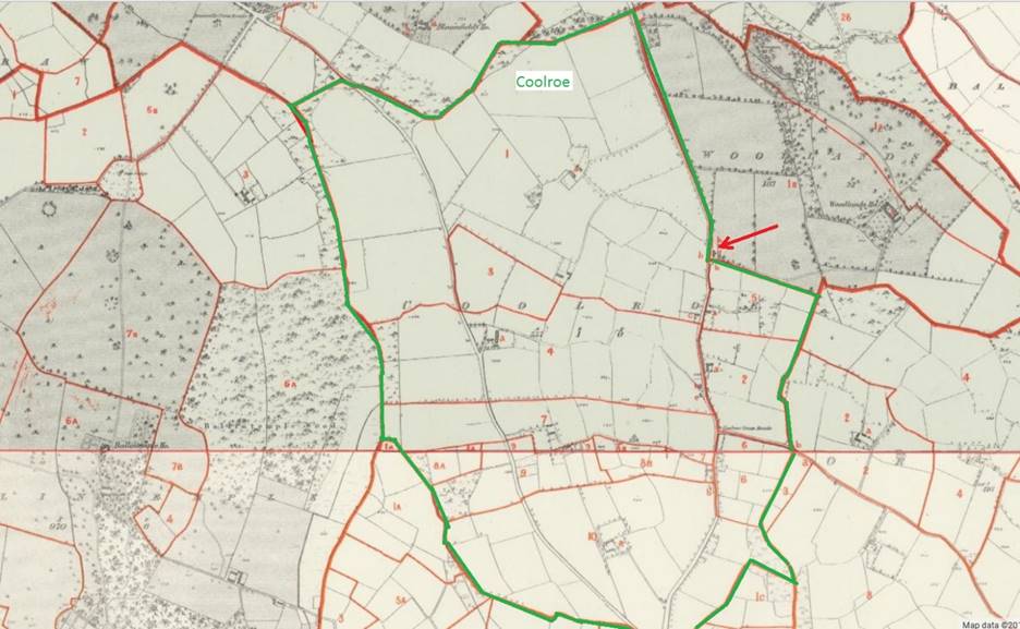
Map of Coolroe, County Carlow, Ireland outlined in green. The red arrow points to the house of William Brien and his family.
An expanded view of the map above, given below, clearly shows subsection 1 and the letter b is visible at the bottom right of the map. Examination of the map shows there is a road to the right of the house and the house is located at the intersection with another road that goes to the right (Note: both roads are slightly obscured by the red subsection lines).
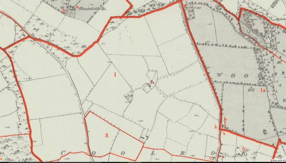
Expanded view of Coolroe, subsection 1. William Brien’s house is identified by the letter b on the right side of subsection 1, opposite the intersection of two roads.
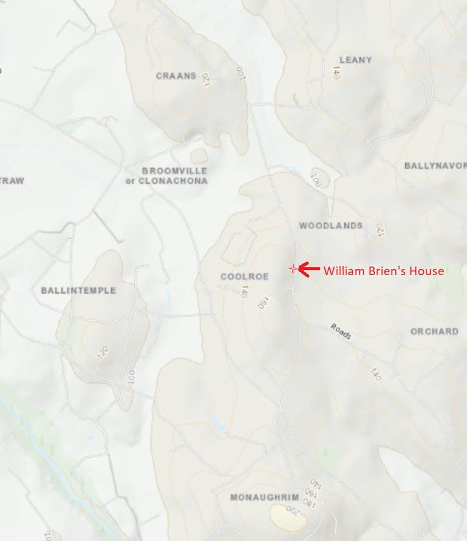
The maps presented at Ask About Ireland are made available by Google, and the site includes the option of fading to modern maps of the area being viewed. Selecting a point half way between the old and modern maps with satellite view produced the map shown below. William Brien’s house is just to the right of the red arrow.
The satellite view shows that the area is still farm land. The large complex above William Brien’s house and to the left is the area identified as being occupied by Henry Bruen’s herd’s house, office and land. There are a couple of barn like structures near the site of William Brien’s house marker, but no structure is at that exact location. The GPS coordinates for the location of William Brien’s house are 52°44'22.2"N 6°39'49.6"W.

Expanded view of Coolroe, County Carlow with a modern satellite map superimposed on the Ordinance Survey map show before. William Brian lived in a house to the right of the red arrow at the location marked b.
Possible father of William Brien
The book “Clonegal in 1798” identifies the members of the Roman Catholic parish of Clonegal who were forced to take a Loyalty Oath in 1797. This list was reviewed to see if any of them may have been William Brien’s father. The list of people who signed the oath in 1797 included John Brien and Charles Brien, both residing in Cranemore. John is the given name of William and Anna Brien’s first son, John W. O’Brien. The naming tradition at the time was to name the first-born son after the father’s father. William and Anna’s youngest child, Thomas O’Brien, my great grandfather, had one son named Charles. Though not following the naming tradition, at least Charles is a family.
It is possible that neither John or Charles Brien are William’s father but perhaps his siblings or other relatives. If they are the same people, then they must have been in their late 60s or early 70s when the Griffith’s Valuation was collected. For the time being, it is assumed that John Brien is William Brien’s father and that Charles Brien is his uncle. The townland of Cranemore is much larger than Coolroe. Therefore, only a portion of Cranemore is shown in the map below. Land rented by John Brien is outlined in green and the land rented by Charles Brien is outlined in blue. Both rented from Reverend Alexander Durdon. Reverend Durdon does not appear to be the actual land owner as he is listed as the tenant of another property in Cranemore with a William Cooper being the Immediate Lessor. Based on the fragmented nature of the land rented by John and Charles Brien, it is likely they were farmers without a sizable herd of cattle.
Map of part of Cranemore townland, County Carlow from Ask About Ireland. Land rented by John Brien is outlined in green and the land rented by Charles Brien is outlined in blue.
William Brien’s occupation
As mentioned above, Henry Bruen is identified as the owner of most of the properties in Coolroe. The description of Henry Bruen’s Coolroe listing is “Herd’s house, offices, and land” which probably means it has a barn and the land was for the cows to graze. According to Wikipedia, there were three Henry Bruens, father (1741 –14 December 1795), son (1789–1852), and son of son (1828–1912), who were members of the Irish parliament representing County Carlow from 1790 to 1880. Based on records at the National Library of Ireland, the Bruens were major landholders and had many tenants on their land. Estate records indicate that some tenets paid rent to Henry Bruen based on their crop or herd size. It is likely that William Brien worked on the farm of Henry Bruen as his Griffith’s Valuation listing only indicates he occupies the house without any mention of land. A farm the size of Henry Bruen’s would typically employ many workers throughout the year [3].
The modern topographical map of Coolroe shown below was obtained from the Ordinance Survey of Ireland web site. The red x marks where William Brien’s house was located. The area just above the word Broomville is where Henry Bruen’s herd house was located. It is noticed that the area is somewhat hilly, with several peaks in the 120 to 160 foot level. The hills would make this land more suitable as a pasture as opposed to growing crops.
Reference [3] provides an excellent review of farming life in County Carlow in the 1700s. Although this is slightly before William Brien’s time, it is doubtful that much changed in the interim years, as the review indicates much of the activities and methods discussed in [3] still applied in the early 1900s. Reference [3] indicates the farms products were wheat, oats, cattle, sheep (occasionally), and turf. It also mentions a concern of the farm manager that the workers would be busy planting their own potatoes instead of working on the farm.
Topological map of Coolroe, County Carlow, Ireland obtained from the Ordinance Survey of Ireland web site. The red x marks where William Brien and his family lived.
Anna E. Kelly’s parents
Attention is now turned to William’s wife, Anna E. Kelly. Her death certificate states that her father was Martin Kelly and her mother’s first name was Mary. A Martin Kelly is listed in the book “Clonegal in 1798” and his address is given as Lackabeg Township, County Carlow. The list is for a Loyalty Oath that was taken in 1797. The book explains that the oath was forced on the people of the Myshall/Kildavin area in 1797 by Robert Cornwall. The list indicates that Martin Kelly was literate. Anna was born in 1812, making this Martin Kelly a possible match. The Griffith’s Valuation does not list a Martin or Mary Kelly in Lackabeg, but there is a Catherine Kelly. It is assumed that Catherine is another daughter of Martin and Mary Kelly. The Griffith’s Valuation table below shows Catherine Kelly has a house and yard listed at location 6e.
Griffith’s Valuation table from Ask About Ireland listing the occupants of houses in Lackabeg, County Carlow, Ireland. Catherine Kelly’s listing is outlined by the red box.
Lackabeg is outlined in green in the map below. In the lower right of the outlined area is Section 6 and the red arrow is pointing to properties a through n. Catherine Kelly lived in one of these houses.

Lackabeg, County Carlow, outlined in green. In the lower right of the outlined area is Section 6 and the red arrow is pointing to properties a through n. Catherine Kelly lived in one of these houses.
Michael McDonnell
A search was made for Michael McDonnell, as there is a marker for him in the O’Brien plot in St. Mary’s Cemetery in Dunkirk, New York. It is believed that Michael McDonnell came to New York with Anna E. O’Brien and they may have married. The Griffith’s Valuation table below shows there was a Michael McDonnell in the town of Clonegal. The entry is for land only, indicating Michael McDonnell lived elsewhere. There are several other listings for McDonnells, some with houses and some with just land.
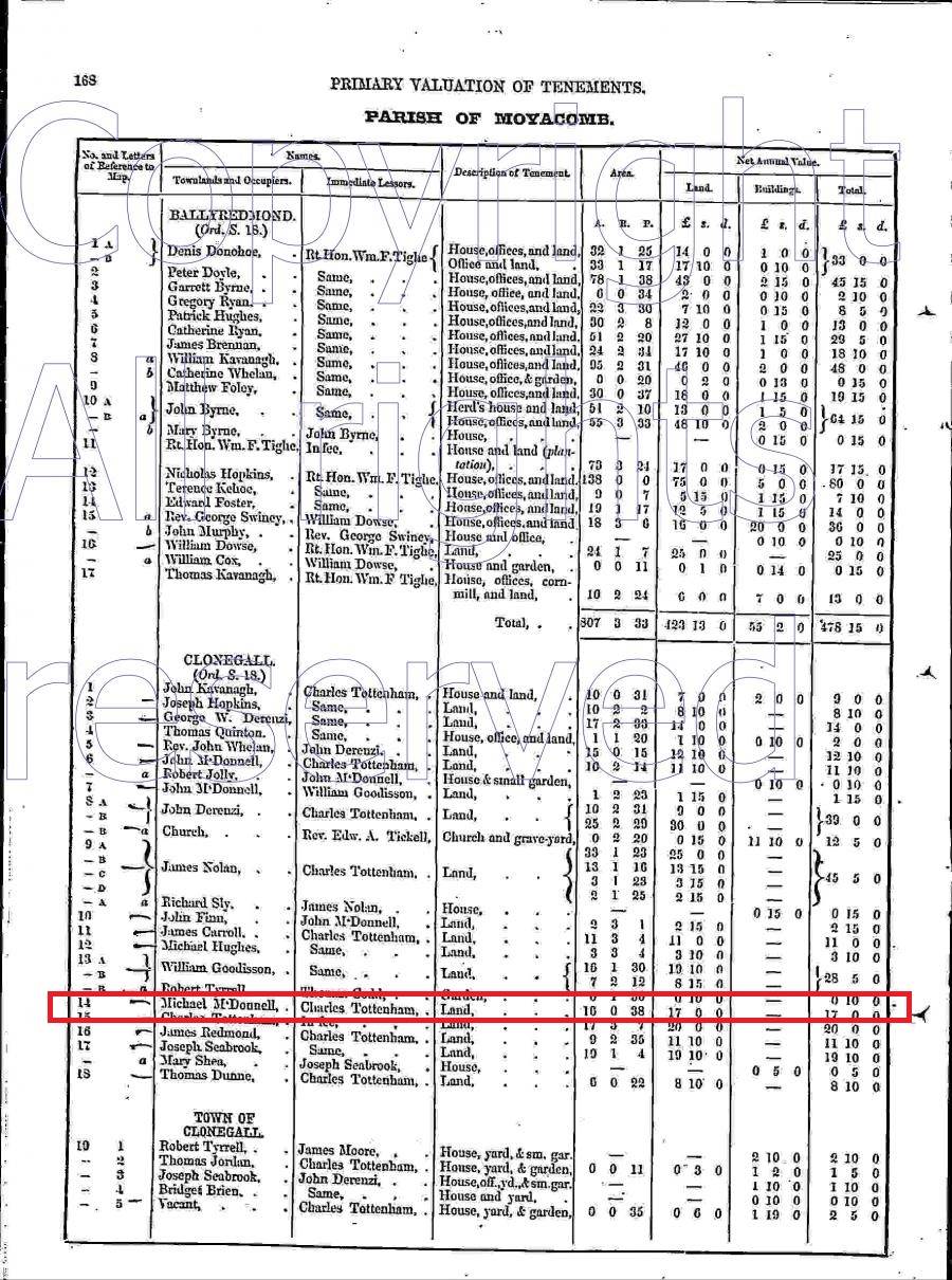
Griffith’s Valuation table from Ask About Ireland listing the occupants of houses in the town of Clonegal, County Carlow, Ireland. Michael McDonnell’s listing is outlined by the red box.
Existing census information and more
It has been well documented that the census information of real interest no longer exists. The 19th century censuses were either shredded for making paper or burned during the troubles in the early 20th century. The table below shows census information collected in 1659 [4]. The information is very sparse, providing only the number of Irish, English, and total population of each townland. Although the spellings of St. Mullins, Clonegal, and Coolroe are different, it is believed that these are the same townships discussed above. Lackabeg did not appear in the 1659 records but Kildovan is very close to Lackabeg and it is assumed that it included what is now Lackabeg. It is noted that the surname Kelly is present in the list of principal Irish names. These numbers are for the Barronyes of Idrone and St Molins combined, not just the three townlands shown in the table.
Information from “A Census of Ireland” c. 1659 ...ed. Seamus Pender. Dublin: Stationery Office, 1939. Contributed by Susie Warren and published on the Carlow County – Ireland Genealogy Project [4].
|
(folio 14). Barronyes of Idrone & St Molins: Eng, 136; Irish, 2282 ; 2418, total. |
||||
|
Towneshippes |
Number |
Tituladoes Names |
Eng |
Irish |
|
Kildovan |
014 |
Nicholas Deuerax gent |
--- |
014 |
|
Clonegan |
031 |
Christopher Fitzgerrald gent |
--- |
031 |
|
Coleroe |
016 |
|
006 |
010 |
|
Principal Irish Names [and] Their Number. Bolger, 013; Byrne, 064; Brenan, 016; Bane, 011; Butler, 012; Curren, 022; Ô Clovan, 005; Doyle, 040; Daniell & McDanll, 014; Duffe, 012; Dillan, 006; McEdmond, 006; Foly, 010; Farrell, 007, 007; Gehinn, 006; Hogan, 006; Ô Headen, 011; Ô Hugh & McHugh, 010; Hicky, 00 ; McJames, 005; Kenselagh, 014; Kauanagh, 039; McKeoghe, 005; Kelly, 017; Lenan, 013; Lawler, 011; Murry, 005; Moore, 010; Murphy, 061 ; Magher, 005; Nolan & Noland, 034; Neale & O Neale, 025; Poore, 007; Perdergras, 018; Roe, 010; Ryan, 031; McShane, 006; Tomin, 011; Walsh, 033. |
||||
Although not a census, the following description accompanying the Griffith’s Valuations [2] provides some general information on the townland of Clonegal, including the fact that its population was 446, a significant increase from the 31 inhabitants in 1659:
CLONEGAL, a post-town, in that part of the parish of MOYACOMB which is in the barony of ST. MULLINS NORTH, county of CARLOW, and province of LEINSTER, 14¼ miles (S. E. by E.) from Carlow, and 53½ (S. S. W.) from Dublin; containing 446 inhabitants. It is situated on the road from Tullow to Newtownbarry, and on the river Derry, which divides it into two parts, and in 1831 comprised 76 houses. Fairs are held on July 31st, Nov. 12th and 22nd, and the first Wednesday in and the 11th of December, for cattle; fairs for the sale of frieze were formerly held on the first Wednesdays in February, March, and May, and on Ascension-day, but have been discontinued. Here is a constabulary police station. The parish church, a good modern building, is situated in the town; and there are a R. C. chapel, a place of worship for Methodists, and a handsome school-house in connection with the National Board, lately built. Here is also a castellated mansion built by the family of Esmonde, in 1625.
The County Carlow, Ireland Genealogy Projects web site includes a listing of marriages in the Parish of Clonegal. Although there were several listings for Brien, none were in Coolroe, Clonegal, or Lackabeg. However, a John Kelly of Lackabeg married Mary Tyrell of Clonegal on July 24, 1882 [5]. Based on date, this John Kelly may have been a nephew of Anna E. Kelly O’Brien.
The next available census is for 1901. The National Archives of Ireland provides the 1901 Census on-line in a searchable format [6]. The following three tables present the search results for surnames of Brien and Kelly in the Clonegal area. The two tables of Kellys show the townland as Jackabeg but these same families show up in Lackabeg in the 1911 Census, so it is assumed this is a typo.
Residents of house 4 in Ballyshancarragh (Clonegal, Carlow) in 1901.
|
Surname |
Forename |
Age |
Sex |
Relation to head |
Religion |
Birthplace |
Occupation |
Literacy |
Irish Language |
Marital Status |
Specified Illnesses |
|
Brien |
Michael |
75 |
Male |
Head of Family |
Roman Catholic |
Co Carlow |
Pensioner R I Consty |
Read and write |
- |
Not Married |
- |
Residents of house 18 in Jackabeg (Clonegal, Carlow) in 1901.
|
Surname |
Forename |
Age |
Sex |
Relation to head |
Religion |
Birthplace |
Occupation |
Literacy |
Irish Language |
Marital Status |
Specified Illnesses |
|
Kelly |
Patrick |
33 |
Male |
Head of Family |
Roman Catholic |
Co Carlow |
Labourer |
Read |
- |
Not Married |
- |
|
Gahan |
Kate |
38 |
Female |
Cousin |
Roman Catholic |
Co Wexford |
- |
Read and write |
- |
Not Married |
- |
Residents of house 5 in Jackabeg (Clonegal, Carlow) in 1901.
|
Surname |
Forename |
Age |
Sex |
Relation to head |
Religion |
Birthplace |
Occupation |
Literacy |
Irish Language |
Marital Status |
Specified Illnesses |
|
Kelly |
Thomas |
29 |
Male |
Head of Family |
Roman Catholic |
County Carlow |
Agricultural Labourer |
Read and write |
English |
Married |
- |
|
Kelly |
Bridget |
28 |
Female |
Wife |
Roman Catholic |
County Carlow |
- |
Read and write |
English |
Married |
- |
|
Kelly |
James |
33 |
Male |
Brother |
Roman Catholic |
County Carlow |
Agricultural Labourer |
Cannot read |
English |
Not Married |
- |
In the 1911 Census, only the two Kelly households from 1901 show up, as provided in the tables below. This indicates there may be Kelly relatives still living in the Clonegal area, as the members of both families were born in County Carlow. It is noted that their occupations are farm or agricultural laborers.
Residents of house 14 in Lackabeg (Clonegal, Carlow)
|
Surname |
Forename |
Age |
Sex |
Relation to head |
Religion |
Birthplace |
Occupation |
Literacy |
Marital Status |
|
Kelly |
Patrick |
47 |
Male |
Head of Family |
Roman Catholic |
Co Carlow |
Labourer |
Cannot read |
Single |
|
Gahon |
Kate |
50 |
Female |
Relative |
Roman Catholic |
Wexford |
- |
Cannot read |
Single |
Residents of house 1 in Lackabeg (Clonegal, Carlow) in 1911.
|
Surname |
Forename |
Age |
Sex |
Relation to head |
Religion |
Birthplace |
Occupation |
Literacy |
Marital Status |
|
Kelly |
Thomas |
40 |
Male |
Head of Family |
Roman Catholic |
Co Carlow |
Farm Labourer |
Cannot read |
Married |
|
Kelly |
Bridget |
38 |
Female |
Wife |
Roman Catholic |
Co Carlow |
- |
Read and write |
Married |
|
Kelly |
Maggie |
10 |
Female |
Daughter |
Roman Catholic |
Co Carlow |
Scholar |
Read and write |
Single |
|
Kelly |
Mary |
8 |
Female |
Daughter |
Roman Catholic |
Co Carlow |
Scholar |
Read and write |
Single |
|
Kelly |
John |
6 |
Male |
Son |
Roman Catholic |
Co Carlow |
Scholar |
Read |
Single |
|
Kelly |
Katie |
3 |
Female |
Daughter |
Roman Catholic |
Co Carlow |
- |
Cannot read |
- |
|
Kelly |
James |
43 |
Male |
Brother |
Roman Catholic |
Co Carlow |
Farm Labourer |
Cannot read |
Single |
|
Murphy |
John |
41 |
Male |
Brother in Law |
Roman Catholic |
Co Carlow |
Farm Labourer |
Cannot read |
Single |
Conclusion
Although the available records are limited, it has been established where Anna E. Kelly and William Brien lived in County Carlow, Ireland. This is significant as it provides some clues to their life in Ireland. The area where they lived has remained relatively unchanged, although the house where they lived does not appear to have survived. William Brien was a tenant of Henry Bruen. This may be an important discovery, as the National Library of Ireland holds two collections of papers for the Bruen’s titled “Bruen of Oakpark Papers.” Among the items identified in these collections are farm records during the late 18th and 19th centuries including records for Coolroe. Anna E. Kelly’s parents were known to be Martin and Marry Kelly from Anna’s death record. This research found that a Martin Kelly lived in the townland of Lackabeg, County Carlow, in 1797. No additional records were found for Martin or Mary Kelly, but the Griffith’s Valuation collected in the 1840s lists a Catherine Kelly in the townland of Lackabeg. Whether this Catherine Kelly is a relation of Anna E. Kelly Brien is unknown. It was also found that at least two Kelly families lived in Lackabeg as late as 1911, indicating there may be relatives still living in the area. However, it appears that the presence of Briens in the area ended sometime between 1901 and 1911.
References
1. Bob Gray, Researching My Mother’s Irish Roots, March 2016, Updated July 2017, http://www.robertfgray.com/history/Researching_My_Mothers_Irish_Roots.html
2. Ask About Ireland, Griffith’s Valuations, http://www.askaboutireland.ie/griffith-valuation/
3. Farming in the Eighteenth Century Carlow, John Monahan, The CARLOVIANA, 1983, http://www.rootsweb.ancestry.com/~irlcar2/farming_1700s.htm
4. A Census of Ireland, circa 1659: with supplementary material from the Poll Money Ordinances (1660-1661), Seamus Pender, editor, Dublin, 1939, http://www.rootsweb.ancestry.com/~irlcar2/A_Census_of_Ireland_c1659_3.htm
5. Carlow County - Ireland Genealogical Projects, Marriages, Clonegal Parish 1871-1900 http://www.rootsweb.ancestry.com/~irlcar2/Marriages_Clonegal.htm
6. National Archives of Ireland, Census, http://www.census.nationalarchives.ie/
Back to family history | Home (Including Site Search) | Bob Gray Consulting | Genealogy | Oswego Maps
Copyright 2017, Robert F Gray