The Grays of Connecticut and Bedford, New York
Bob Gray, January 2019
On our third family history trip, my brothers, Brien and Barry, and I went to explore our family’s time in Connecticut and Bedford, New York. Our focus was mostly on the male Gray line from our fourth great grandfather, Hezekiah Gray, on back to our seventh great grandfather, Henry Gray Sr. We also looked for several Beckwiths, as another fourth great grandfather, Elisha Beckwith, lived in Connecticut and died at the Battle of White Plains on October 28, 1776.
We started our trip in Old Lyme, Connecticut where many of the Beckwiths settled in the mid-1600s and worked our way west to Bedford, New York, just as our fore fathers had done. The following paragraphs present our travel including major findings about our family and some of the fun we had along the way.
Old Lyme, New London, Connecticut
Our time in Old Lyme was divided between the Old Lyme Historical Society, the Old Lyme Room at the Old Lyme Noyes Library, and several cemeteries. We found several records for Beckwiths in the reference material in the Old Lyme Room. The new information has been added to the individual web pages under my family genealogy directory. Although the Old Lyme Historical Society provided us with maps showing where several potential ancestors were buried, we were not successful in finding many of the gravestones. We couldn’t even find one of the cemeteries, let alone the gravestones. We did have a group photo op as shown below.
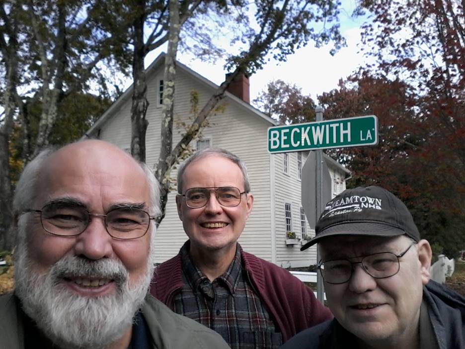
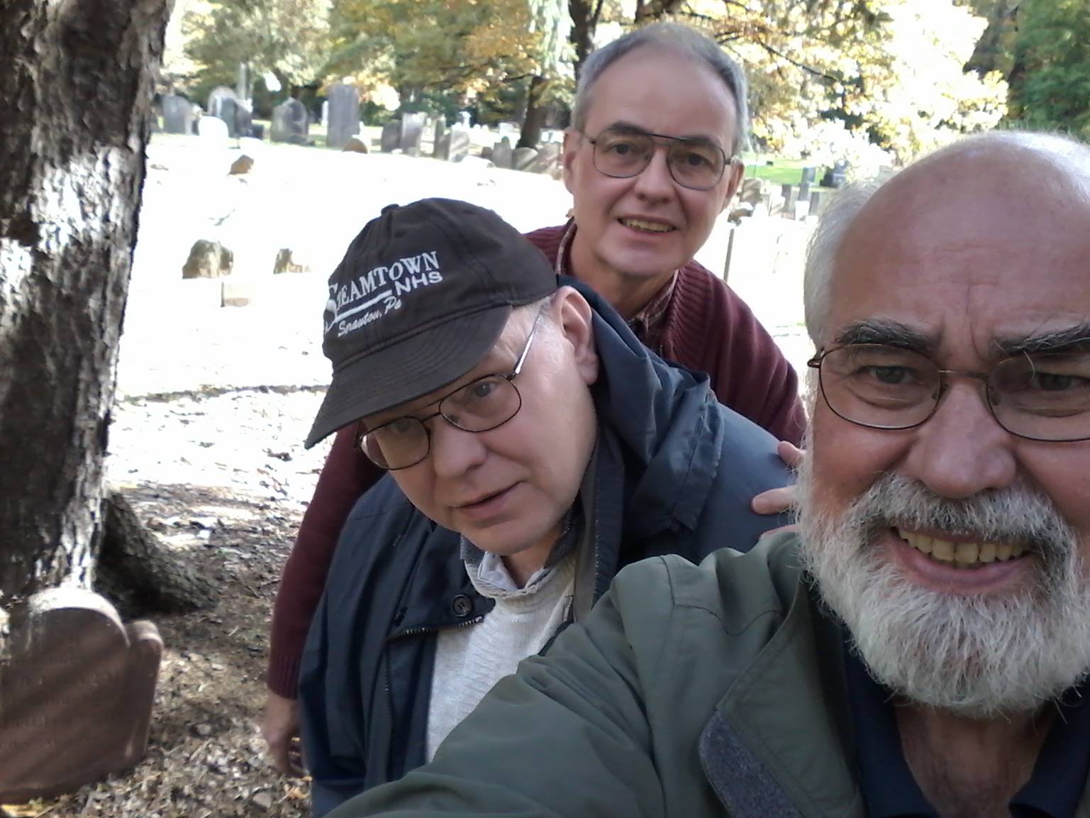
Bob, Barry, and Brien Gray on Beckwith Lane in Old Lyme, Connecticut, October 26, 2018.
Fairfield, Fairfield, Connecticut
After a side trip to the Danbury Railway Museum, we researched the Grays and related families at the Fairfield Museum and History Center. The staff at the history center were wonderfully helpful. Henry Gray Sr, along with his brother John and father-in-law William Frost, settled in Fairfield around 1640. Henry and John were married to William Frost’s daughters Lydia and Elizabeth. Henry Gray Sr, John Gray, and William Frost were some of the first settlers of Fairfield, Connecticut.
The map below is a key to the Block Maps from a book developed by members of the Fairfield Historical Society [1]. The earliest part of Fairfield was in blocks 1 to 4 on the right side of the map below. Many, but not all, of the blocks identified on the map below have larger detailed maps in the book.
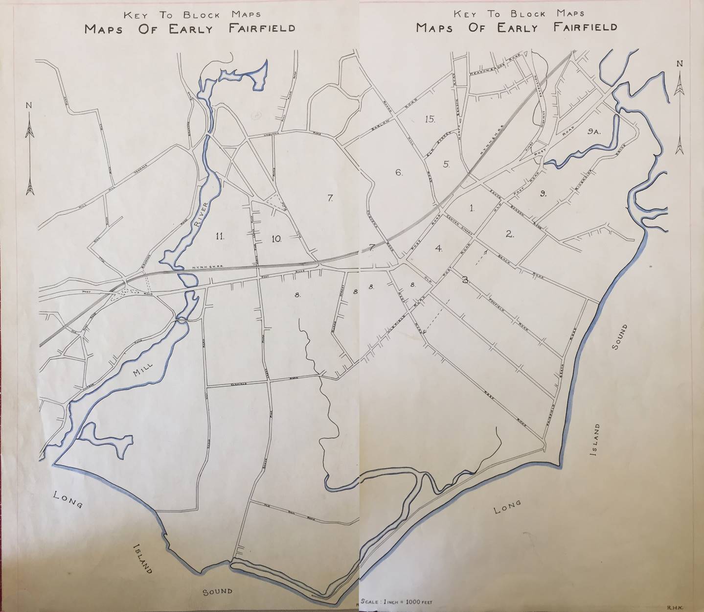
Key to Block Maps in Early Maps of Fairfield [1]
The map of Fairfield below, dated 1648 to 1657, shows William Frost and John Gray owned land there. Henry Gray Sr lived with his father-in-law. William Frost’s son, Daniel, also owned a lot in the same square. The four blocks going clockwise from the upper left are labeled Frost, Ludlow, Newton and Burr Square. Frost Avenue runs along the north edge of Frost Square. According to [2], the squares were laid out by Roger Ludlow in 1639 when he was Deputy Govenor of Connecticut. Each square was about 25 to 30 acres and the squares were named after the first families who settled in them [2]. William Frost’s property was two and one half acres, John Gray’s property was also two and one half acres, and Daniel Frost’s property was three and one half acres [2].
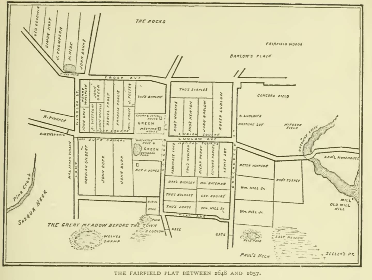
Map of Fairfield, Connecticut dated 1648 – 1657 from the History of Fairfield, Fairfield County, Connecticut [2].
A more detailed view of block 4 or Frost Square is shown in the map below [1]. The book [1] also contains later maps of the same block showing who owned the property in 1779 when the town was burned by the British and in 1936. Neither the Grays or the Frosts owned property in Block 4 in 1779 as they had moved westward to what is now part of Westport. William Frost died in 1645 and left his property in Fairfield to his daughter Lydia and son-in-law Henry Gray with a provision that it would then transfer to his grandson, Jacob Gray, a son of Henry and Lydia Frost Gray. It is believed that Jacob Gray and his family lived in Fairfield until his death in 1712. His second wife Sarah died 1716. The disposition of the land originally owned by William Frost is unknown but the map from 1779 shows no indication that it stayed in the family.
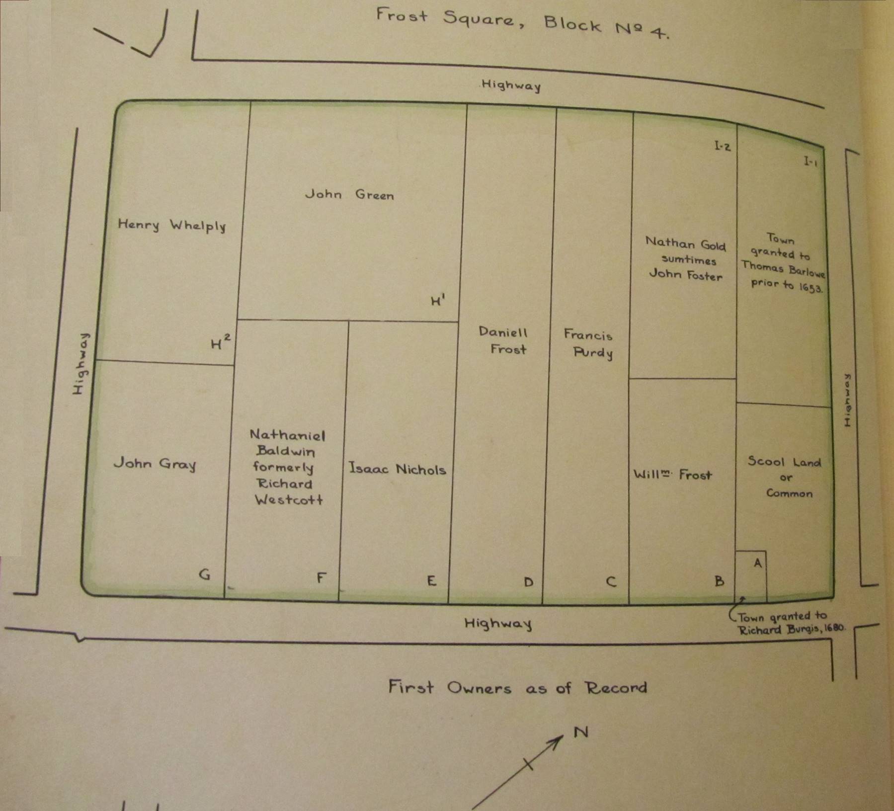
Detailed map of Block 4 or Frost Square showing the first owners as of record, Fairfield, Connecticut [1].
Somewhat surprisingly, the general outline of the four squares still exists in Fairfield today. It takes a bit of imagination, but the Google Earth map below supports this statement. The red square outlines what was known as Frost Square or Block 4 in the maps above. The road on the upper left side of the square is US 1. The road on the lower left and bottom is now called Old Post Road. The upper right side is Beach Road. The Fairfield Museum and History Center is seen to reside in what was called Burr Square or Block 3. Frost Square is about 1,000’ by 1,500’ is size which is about 33 acres. Ludlow Square, to the upper right of the red square, appears to have been modified slightly when the railroad was put in the mid-1800s. Newton Square looks to be unmodified from its original shape.
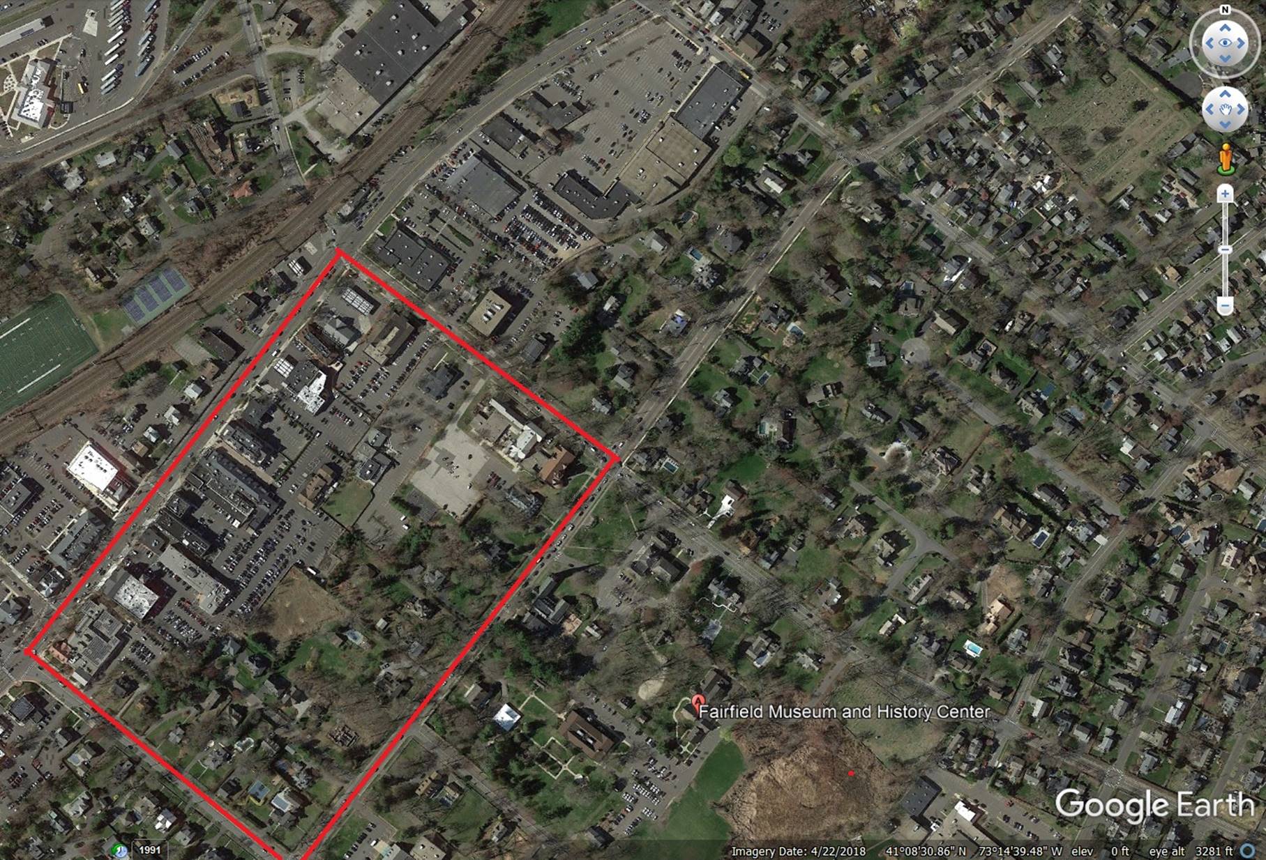
Google Earth view of Fairfield, Connecticut with the area known as Frost Square outlined in red.
The names of the original property owners identified in the map of Fairfield from 1648 to 1657 are listed in the table below. There are a couple of interesting relationships between the people listed in the table. Daniel Frost, Henry Gray Sr, John Green, and Thomas Newton were four of the five Bankside Farmers who moved from Fairfield to Frost Point around 1648. This area is now part of Westport and was our next stop. John Barlow’s daughter Elizabeth married Daniel Frost. Perhaps the most significant relationship was between the Gray family and the Ludlow family, identified in [2] as follows:
“With vast acres of fine timber, and with one of the finest harbors on the coast, the planters of Fairfield, found an abundant source of wealth at hand. Black Rock became, and was for many years called, the sea-port harbor of Fairfield. The family of Grays appear to have been London merchants, and engaged in the New England shipping business with the Ludlow family. There is every reason therefore to believe that vessels were at an early date laden from Black Rock for England, Virginia and the West Indies.”
as it would explain why the Grays and Frosts moved from Boston to Fairfield. The suggestion that the Grays were engaged in the shipping business is supported by early manifests for ships bound for Boston from England. Evidence of the Grays being engaged in the shipping business is provided by two English Public Records Office entries, one on April 4-13, 1639 (PRO: E190/42/3) and another on April 10-20, 1639 (PRO: E190/43/6), which identifies Henry Gray as “shipper of goods” on a ship bound from London to New England [3]. Roger Ludlow is credited with purchasing "all the lands lying west of the Stratford bounds to the Sasqua or Mill river, and from the Mill river south-westward to the east bounds of the Maxumux Indian lands; and from the Sound, seven or eight miles into the wilderness," all of which lands were claimed by the Pequonnock Indians [2].
Names of original property owners identified in Fairfield Map 1648 to 1657.
|
Frost Square |
Ludlow Square |
Newton Square |
Barr Square |
Other Areas |
|
Thomas Barlow |
John Barlow |
Lewis Lot |
John Barr |
John Banks |
|
John Foster |
Robert Hopkins |
Edward Harvey |
Obadiah Gilbert |
George Goodwin |
|
William Frost |
Roger Ludlow |
Richard Perry |
|
William Hill Jr |
|
Daniel Frost |
Thomas Newton |
Thomas Newton |
|
William Hill Sr |
|
John Gray |
Thomas Staples |
George Squires |
|
Simon Hoyt |
|
John Green |
|
Daniel Bulkley |
|
H Hyde |
|
John Nichols |
|
Thomas Bulkley |
|
Peter Johnson |
|
Francis Purdie |
|
William Bateman |
|
Roger Ludlow |
|
R. Westcoat |
|
Thomas Jones |
|
R Pinkney |
|
Henry Whelpley |
|
William Hill Sr |
|
J Thompson |
|
|
|
|
|
Robert Turney |
The size of Frost Square would have been insufficient for the inhabitants to have used as their only farm and pasture land. Some of lots outside the four squares are identified as pasture land. The map of Fairfield County below [2] shows the extent of the county to the north. The Town of Fairfield lies just below the “k” in the label “Black Rock.” The areas labeled East Long Lots and West Long Lots were divided up into somewhat narrow strips that extended all the way to the area labeled Redding on the map below. According to the newspaper article following the map below, the long lots were measured in 1758. Many, but not all, of the Grays had moved further west by this time. A Jacob Gray is listed as one of the owners of Long Lot 1. It is unclear who this Jacob Gray was as Henry Gray Sr’s son Jacob died in 1712 and his son, Jacob Gray Jr died in 1742. Given the presence of several other “Original Property Owners” in the list of Long Lot owners suggests the land may have been informally divided among the settlers of Fairfield prior to the measurements made in 1758.
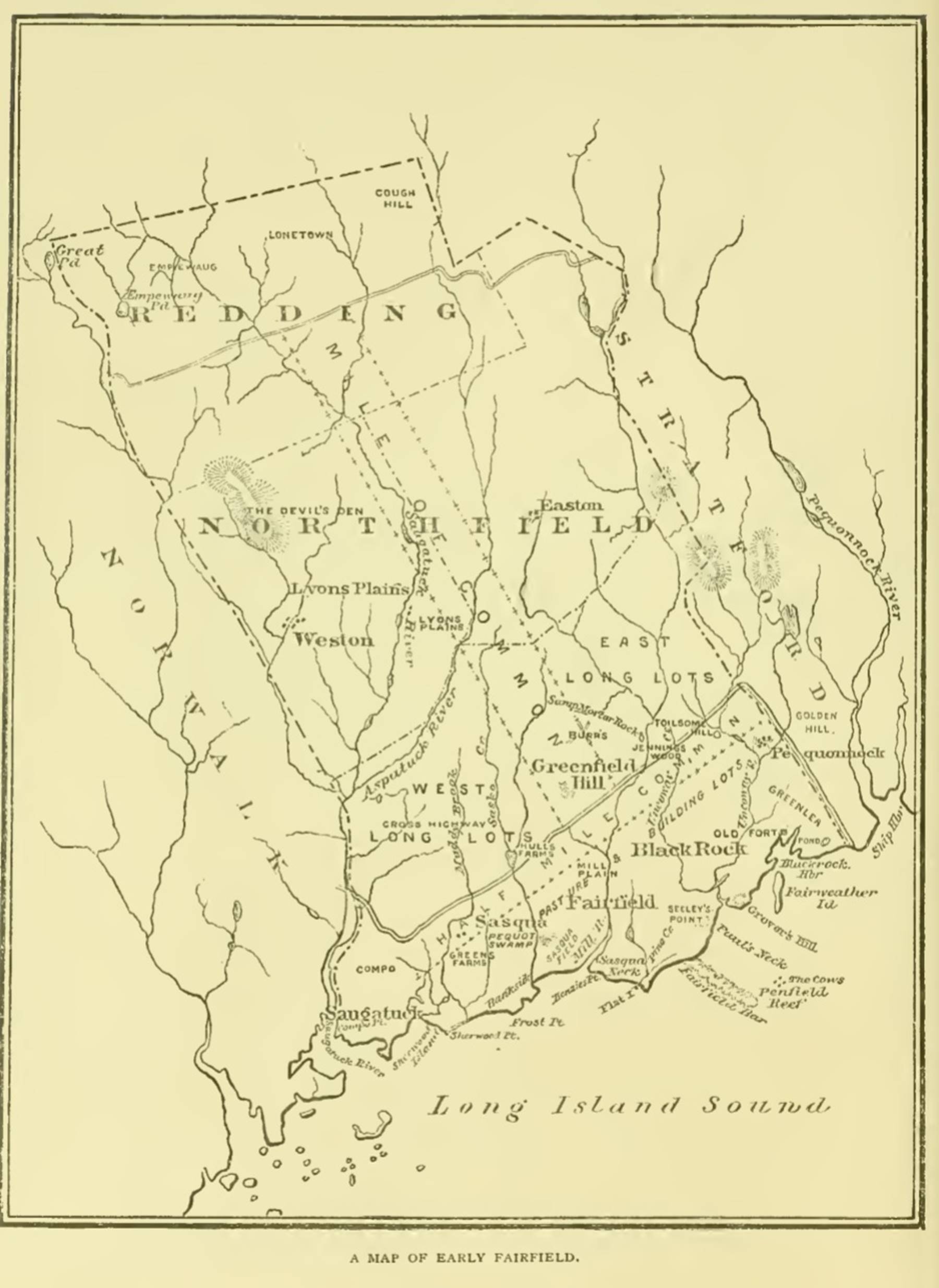
Map of Early Fairfield County showing the long lot areas to the north and Frost Point/Bankside area to the west of the town along Long Island Sound [2].
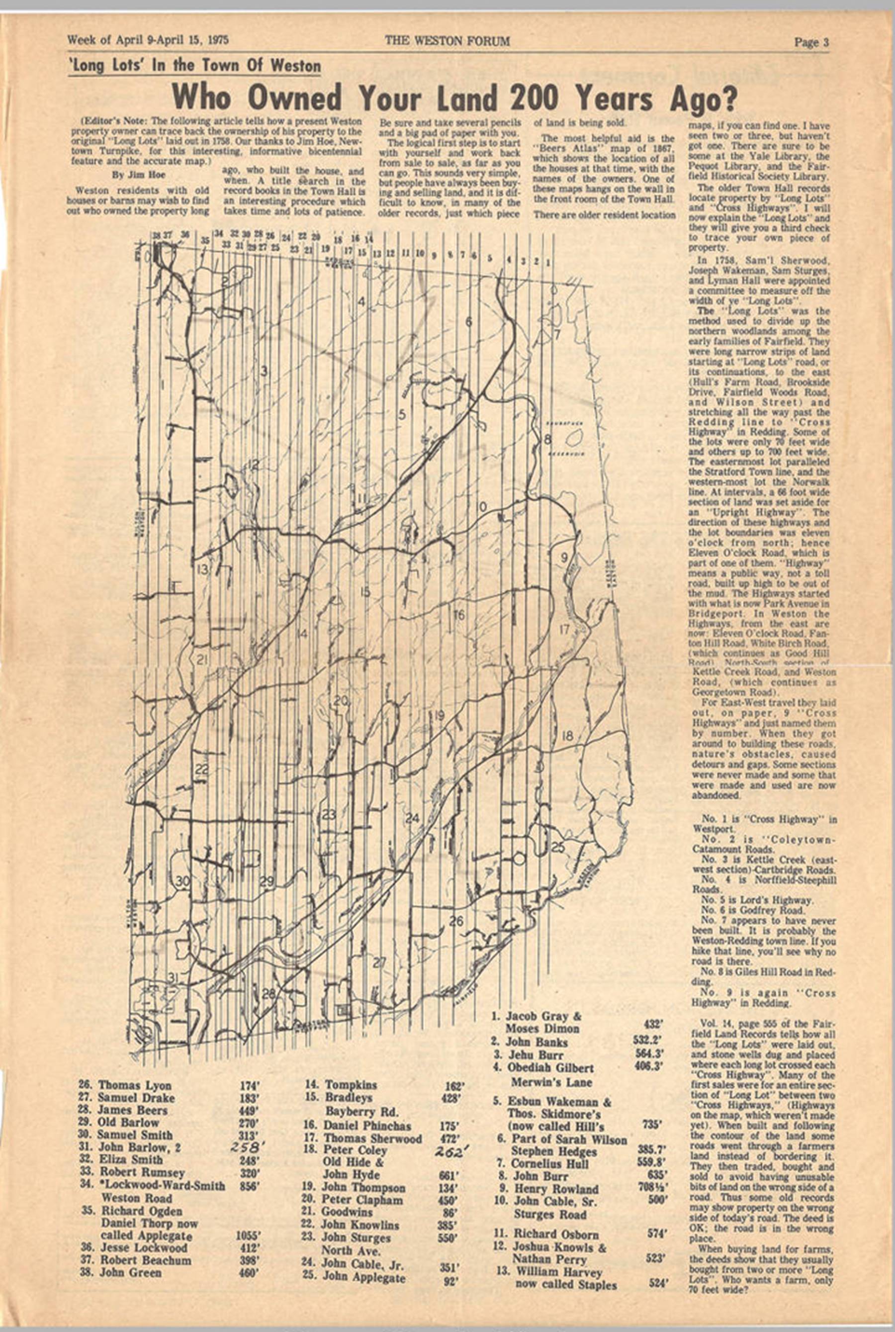
The Weston Forum newspaper article dated April 9-15, 1975 identifying the owners of the Long Lots [4].
Henry Gray Sr was one of the Five Bankside Farmers, along with David Frost, John Green, Thomas Newton, and Francis Andrews. So, after an unproductive visit to the Colonial Burying Ground, our next stop was Frost Point to see the area where Henry lived. As shown in the map below [5], Beachside Avenue runs past the Bankside Farmers’ properties. Our first stop was Gray Lane which is a private drive off Sasco Creek Road, near its intersection with Beachside Avenue. We couldn’t resist another group photograph shown below the map. Note: I have photoshopped back in the apostrophe s in the sign. I have no idea why it had been blacked out, but Google Maps seems to think Gray Lane is correct. The Town of Westport’s land records identify it as Gray Lane. The majority of the houses on Gray Lane were built in the 1970s and all of them are valued at more than $4 million. I don’t know if the street was ever called Gray’s Lane, but the owners' decision to black out the apostrophe s instead of buying a new sign to correct the name seems a bit silly considering the value of houses on the street. I guess that is why they can afford such expensive houses. Even though the current name for the street is Gray Lane, I prefer to call it Gray’s Lane.
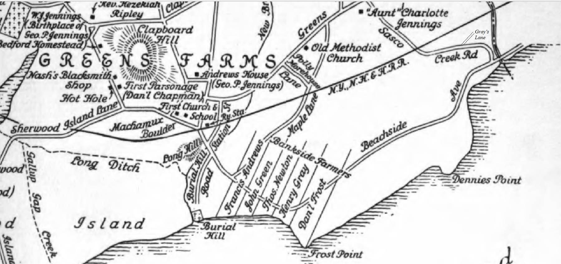
Detailed map of Bankside, Fairfield County, Connecticut showing Henry Gray’s Sr’s property next to Daniel Frost’s property at Frost Point [5].
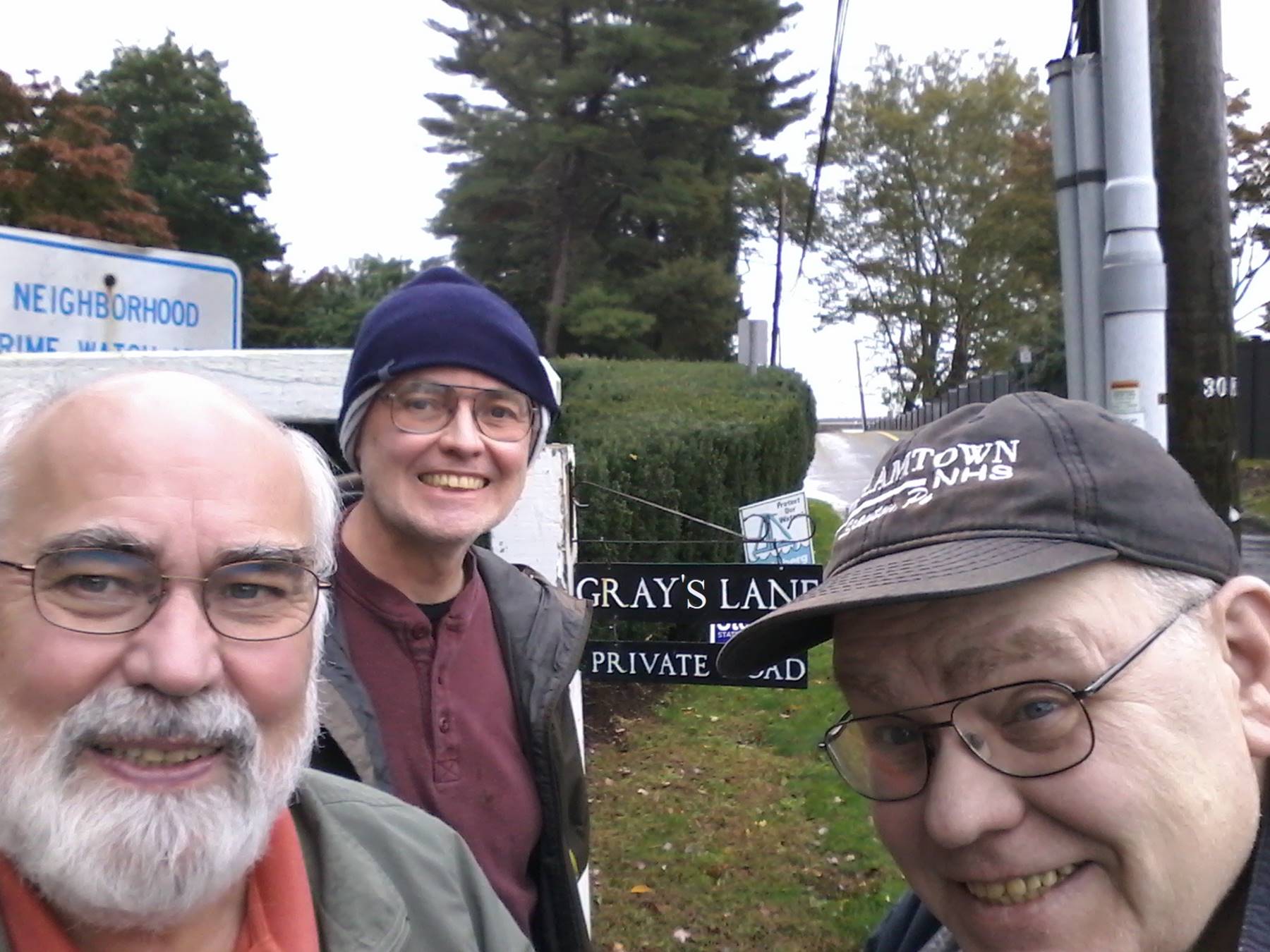
Bob, Barry, and Brien in front of the sign for Gray’s Lane off Beachside Avenue. The owners apparently didn’t like the possessive nature of the name for the lane as they had blacked out the apostrophe s. I have put it back in even though it is officially Gray Lane.
After visiting Gray Lane, we drove along Beachside Avenue to view the area where the Bankside Farmers lived. There are no remnants of Henry Gray’s house as the area has been heavily developed. There was a large storm the day we were there. The view of Long Island Sound from Beachside Avenue with the waves crashing on the cliff were dramatic. One can only imagine the impressive scenes from Henry’s house. Not far from Henry Gray’s property was the plaque shown below commemorating the Bankside Farmers. This sign was the first I had heard of the Jennings Trail. A reference to Jennings Trail showed up again at a later stop at Gray’s Cemetery.
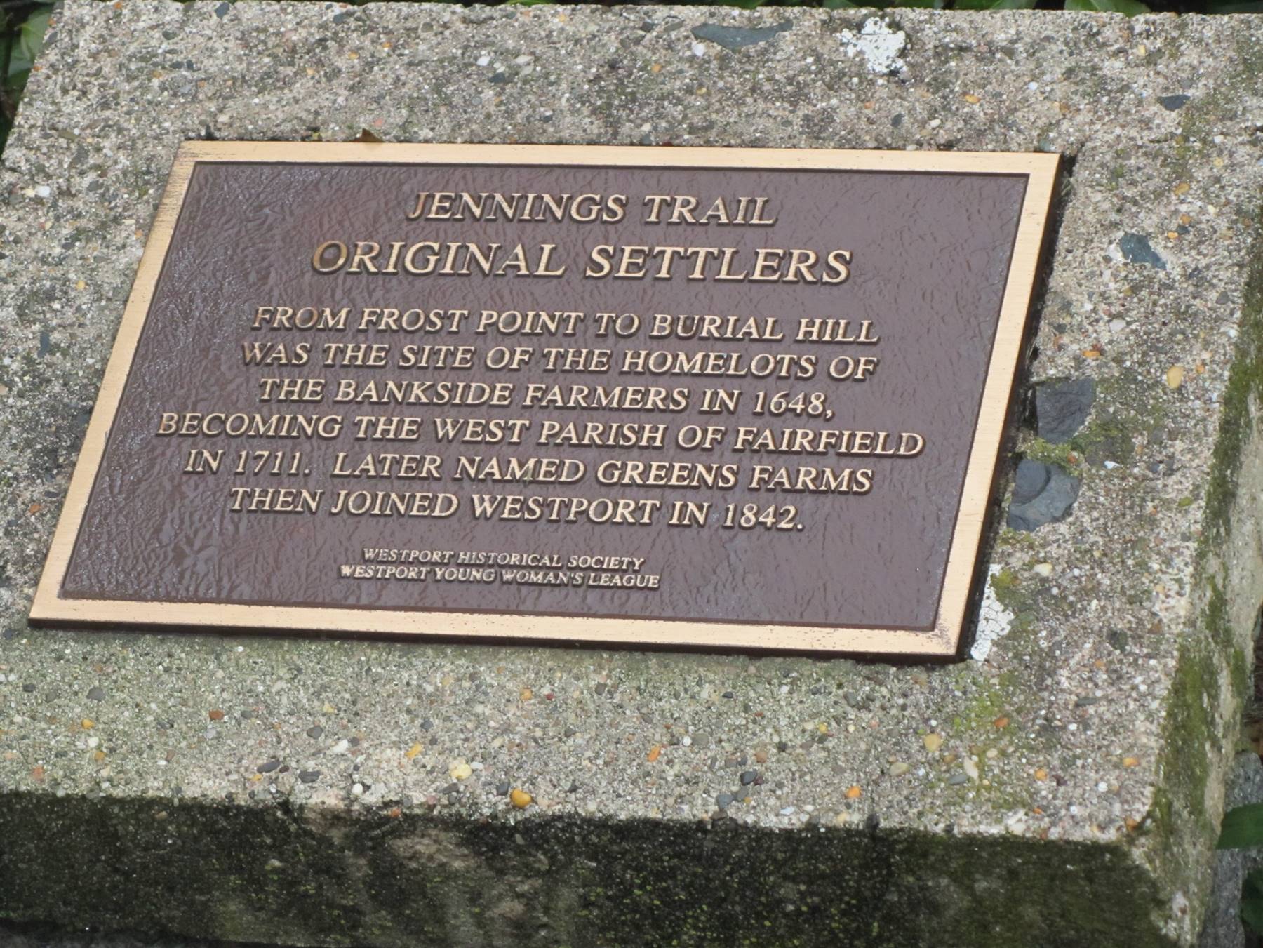
Historical marker on Beachside Avenue near the land owned by Henry Gray Sr in 1648.
A bit of family history is needed before I move on to our next stop. Henry Gray Sr and Lydia Frost reportedly had six children, four boys and two girls. Other than their mention in Gray Genealogy [6], no information has been found on two of their sons, Levi and William. Another reference [7], only identifies two sons, Jacob and Henry Jr along with their daughters, Mary and Sarah. It is assumed that Jacob was their first-born son as he inherited the Frost property in Fairfield discussed above. Jacob stayed in Fairfield when Henry Gray Sr moved his family to Bankside (aka Maxemus after the Indian name for the area). The court document [8] below shows that Henry Gray Sr died without a will.
A Generall Courte held at Hartford, October 8, 1674.
The petition of Major Nathan Gold, Mr. Wm. Hill and Mr. Jehu Burr, being duely considered, this Court see good reason to approue of what the County Court of Fayrefeild haue done, in setleing and passing over Henry Greye's farme, at Maxemus, to Joseph Loekwood the heir of Robert Lockwood, it being the most prudent course in present veiw to reserve any estate for the children of the sayd Grey, and the onely way to pay those just debts which sayd Grey had contracted; and doe therefore hereby impower the administrators of the sayd Henry Greye's estate, by a firm deed of sale, to pass ouer the sayd Grey's farme at Maxemus to the sayd Joseph Loekwood the heir of Robt Loekwood ; and their sayd deed being made, signed, sealed and deliuered according to law, shall be sufficient for the holding of the sayd farm to the sayd Loekwood, his heirs and assignes forever.
The above court ruling indicates that when Henry died in 1658, he must have been heavily in debt to Robert Lockwood as his son, Joseph, was awarded the majority, if not all, of the Gray Bankside property. Henry Gray Sr and Lydia Frost most likely were buried at Burial Hill Cemetery shown on the old map above. The road to the area was closed when we were there due to a storm that day. Google Satellite views and photographs on the Find a Grave web site of the area indicate that no gravestones are visible.
It is known that Henry Gray Jr stayed in the Greens Farms area after his father’s death. The exact location of his house is unknown. He was buried in Gray’s Cemetery which is in Longshore Park near the 13th hole of the golf course. It is also next to Gray’s Creek. Henry Gray Jr’s headstone was preserved by William Gray Harmon and the Compo Hill Chapter of the Daughters of the American Revolution (DAR) in 1936. The face of Henry Gray Jr’s original headstone is shown on the left below and a plaque placed in his honor on the back side of his headstone is shown on the right below.
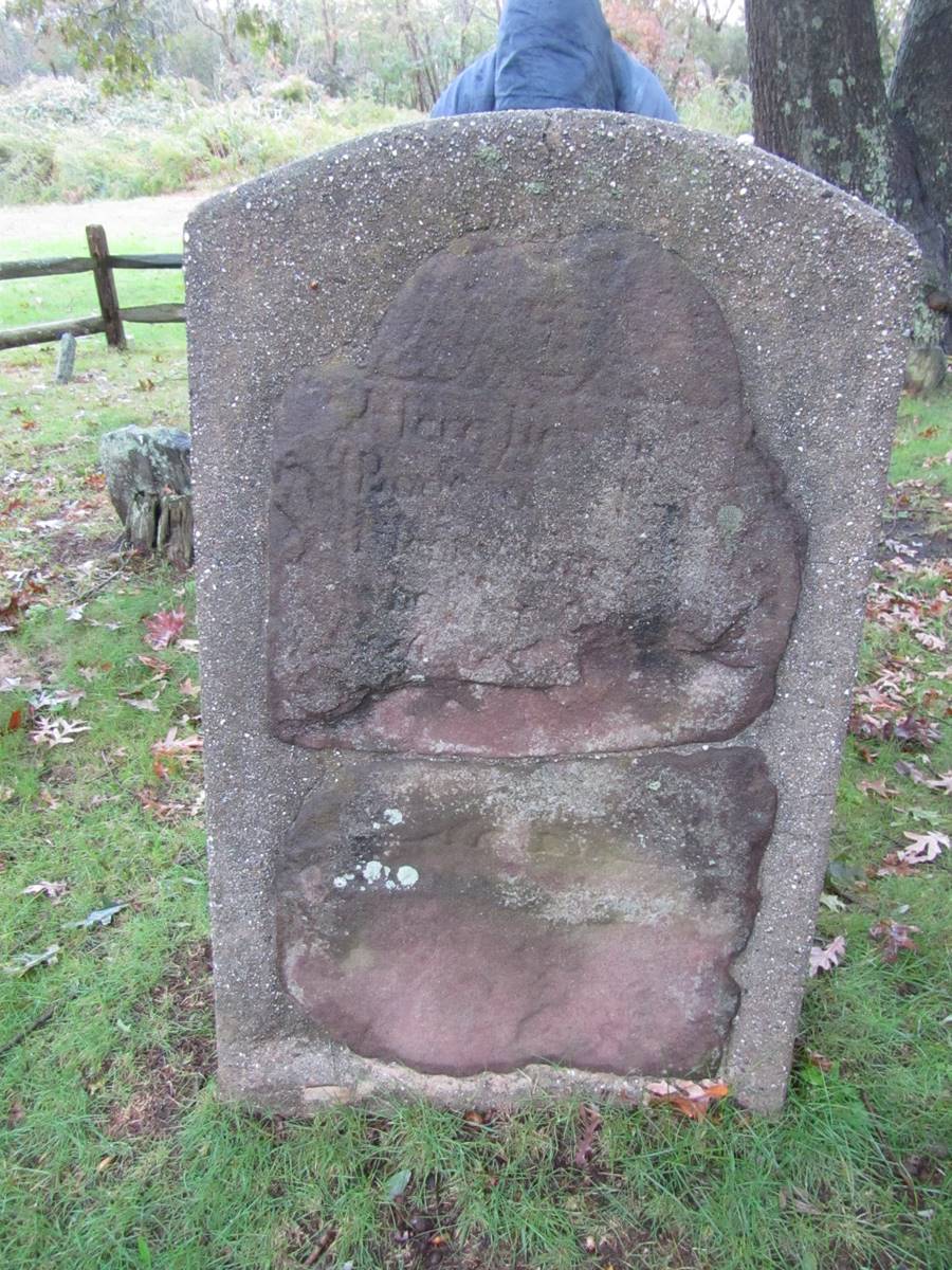
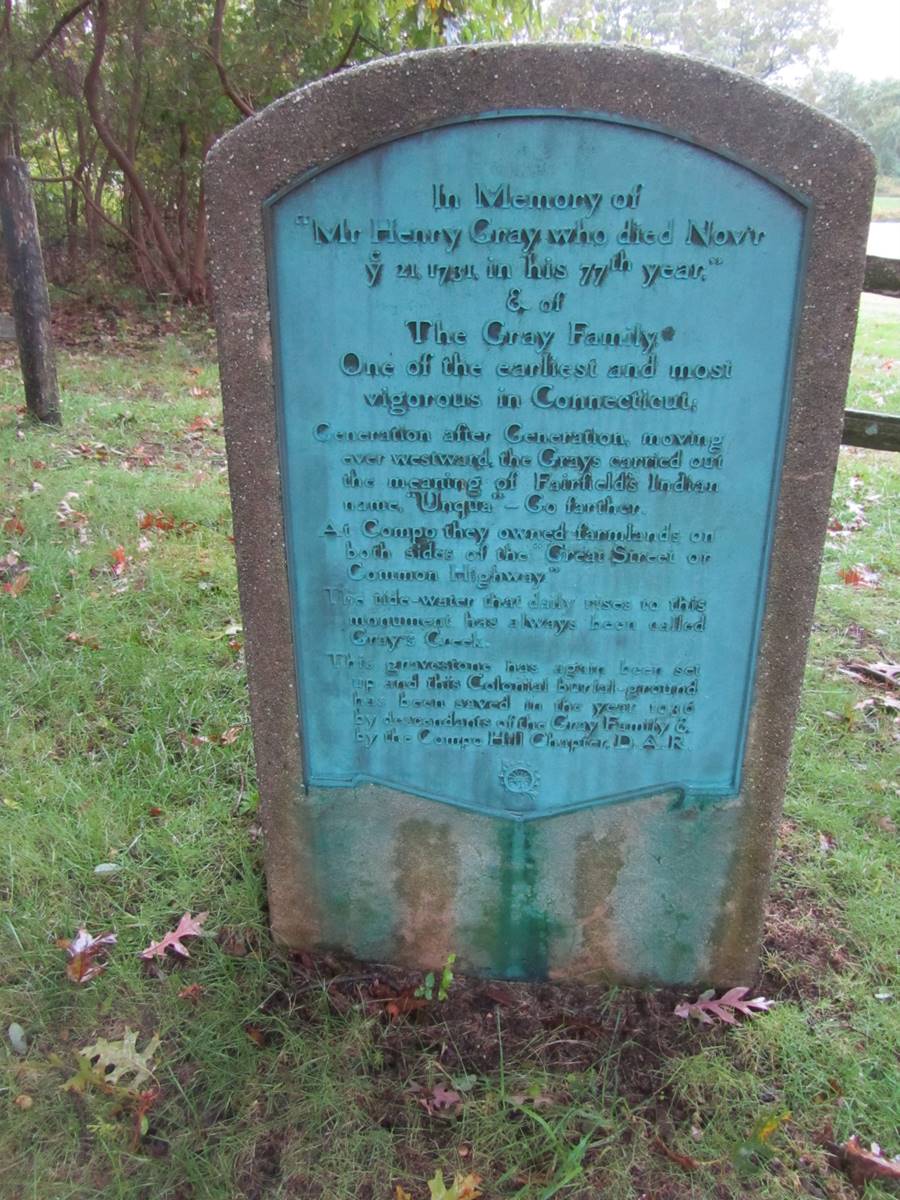
A portion of Henry Gray Sr’s gravestone is seen on the left (or top). The marker on the right (or bottom) is on the back of the original stone’s encasement.
The plaque on the back of the gravestone reads:
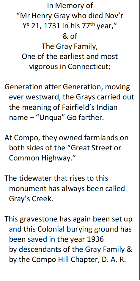 |
and the inscription echoes my earlier statement about the Gray family’s ever westward movement. It also mentions Gray’s Creek which is referenced on the second Jennings Trail marker that we found near the cemetery, shown below. Note that the marker refers to Grays Cemetery without an apostrophe, but the name of the creek includes the possessive mark. Apparently, the use of an apostrophe is somewhat optional as the Friends of Sherwood Island web page indicates either Green’s Farms and Greens Farms is okay. The appearance of the family name obviously called for a pair of group selfies as shown below.
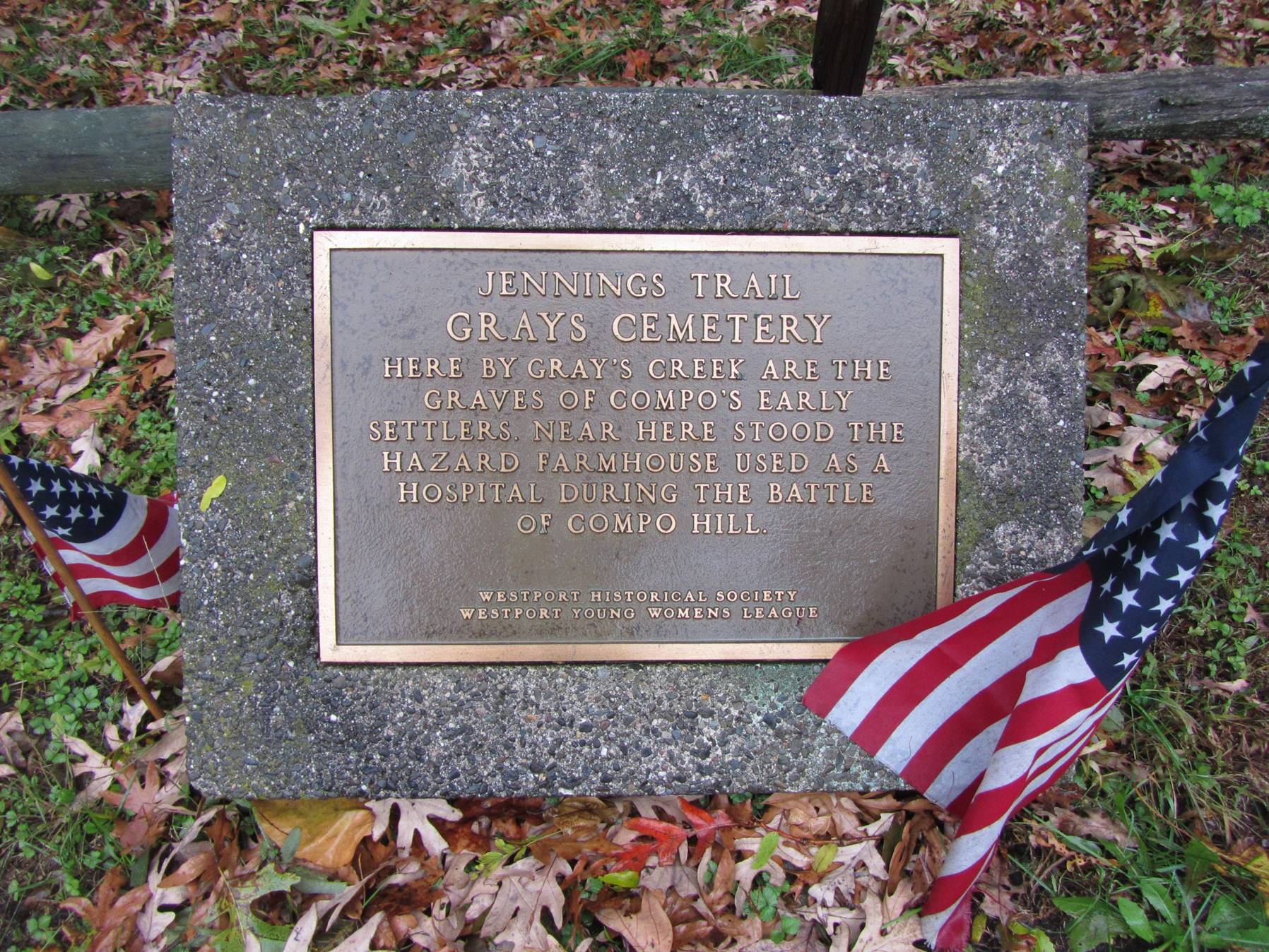
Historical marker for Gray Cemetery in Longshore Park near the 13th hole of the golf course, Westport, Connecticut.
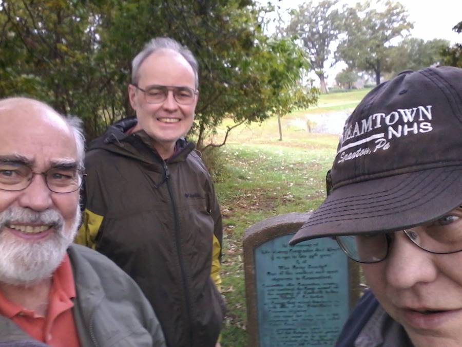
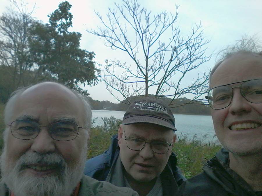
Bob, Barry, and Brien at Henry Gray Jr’s gravestone in Gray’s Cemetery and again by Gray’s Creek, Westport, Connecticut.
I need to do a bit of a Marx Brother’s strange interlude to explore some of the information on the marker before continuing our history trip.
I don’t have any information on William Gray Harmon, or any Harmons for that matter, in my genealogy database. A search on FamilySearch.org identified one person with the name William Gray Harmon who was born in New Jersey in 1887. However, Multiple William G Harmons appeared in the search with similar birth years who were born in Wisconsin, Ohio, Pennsylvania, Maine, Tennessee, Kentucky, Missouri, Kansas, Maryland, South Carolina, Indiana, and Mississippi. None were born in Connecticut. A check of an on-line Harmon Genealogy book produced no reference to him or the Gray family. It appears the Compo Hill Chapter of the DAR is no longer in existence, so there is no assistance there in identifying William Gray Harmon unless the chapter’s papers have been preserved by the DAR. The Find a Grave page for Henry Gray Jr states that William Gray Harmon was “the 10th William Gray in succession.” This claim seems a bit questionable.
The DAR’s role in preserving Henry Gray Jr gravestone seems a bit questionable as well. Henry died well before the Revolution and I have not found any references to military service for him. His singular documented feat, other than his children, seems to have been testifying against Mercy Holbidge Disbrow at her witch trial in 1692 [9]. Mercy was convicted of being a witch and subjected to the water treatment prescribed by law, bound hand and foot and placed in water; as she floated “like a cork” this was evidence of possession. In his testimony, Henry Gray Jr said that Mercy “bewitched his cow, converted a new kettle he bought of her into an old one, and she bewitched a neighbor's cow.” It isn’t clear whether Mercy was killed or pardoned.
I was hoping the reference to the Great Street or Common Highway would help identify where Henry Gray Jr and his children lived after the Bankside property was lost. I looked on several maps, both old and new, and could not find a reference to the “Great Street or Common Highway.” I do know that land was given out at various times to the settlers as it became available, so having land in multiple places makes sense.
Henry Gray Jr and his second wife, Hannah Sanford, had a son, Samuel, who was my fifth great grandfather. Samuel married Ellener Sturgis on October 24, 1734. Based on the baptism records for Samuel and Ellener’s children, they lived in Fairfield County during their early life. There are land records showing Samuel as living in Compo, which is a little further west of the Bankside area. The map below is the complete map inside the cover of [5]. A detailed view of the lower right side was shown above during the discussion of the Bankside Farmers which is the area inside the blue box. Inside the red box are several features with the name of Compo (Compo Hill, Compo Road, and Compo Pond). Gray’s Creek is inside the red box to the left. The current shape of Gray’s Creek, as seen in the following Google Satellite view, differs from the map below but that would be expected after some 300 years. The red and white markers in the Google Satellite view indicate the location of Gray’s Cemetery. Gray’s Creek is just to the right and below the cemetery markers. The map below from [5] identifies Compo Burial Place in about the same area as Gray’s Cemetery if one allows for significant change in the pattern of Gray’s Creek.
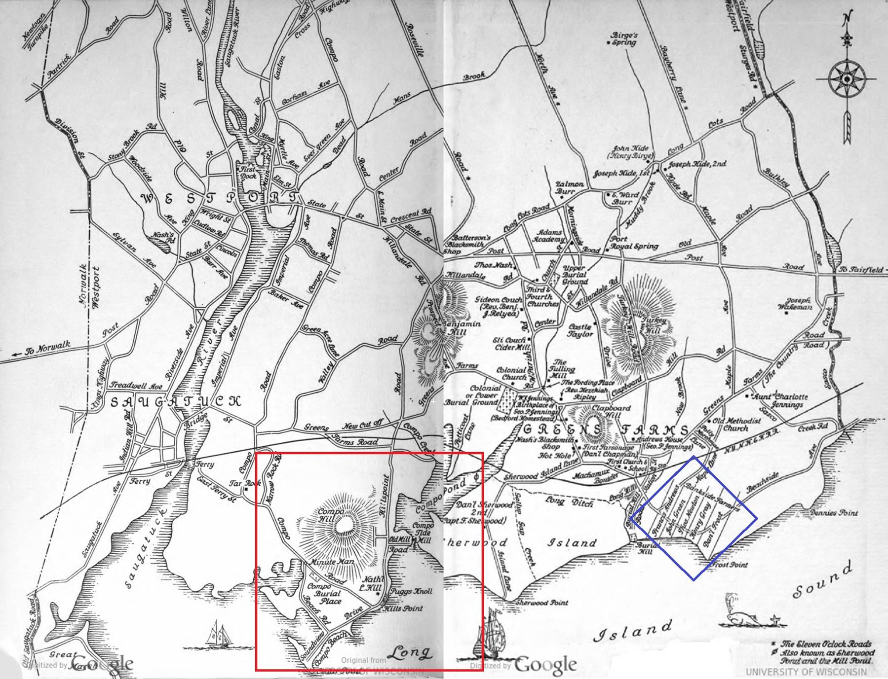
Greens Farms map showing the Bankside Farmers area inside the blue box and Compo area inside the red box [5].

Google Satellite view of approximately the same area as inside the red box in the map above.
At first, I thought the Compo Burying Place became known as Gray’s Cemetery after Henry Gray Jr’s gravestone was the only legible one. However, a check for cemeteries at Find a Grave showed there are two cemeteries. The page for Compo Burial Place (called Compo Colonial Cemetery on Find a Grave) has only the plaque shown below that was placed by the DAR in 1933, three years before the plaque on the back of Henry Gray Jr’s gravestone. It mentions that the cemetery includes members of the Gray family. There are no other details about who is buried there, so it is assumed that the inscriptions were lost over time.
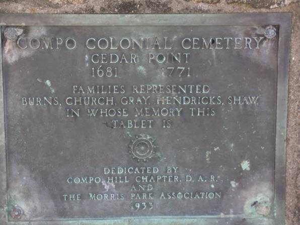
Photograph of the plaque at Compo Colonial Cemetery, aka Compo Burying Place, from Find a Grave.
Given the location of Gray’s Cemetery and the knowledge that Samuel Gray owned property in the Compo area, it seems reasonable that Henry Gray Jr lived in the Compo area after the loss of the Bankside property. Samuel Gray and Ellener Sturges’ second son, Hezekiah Gray Sr, was born on 14 November 1738. Hezekiah married Abigail Waterbury on 24 April 1760. I knew from land records that Hezekiah and Abigail moved to Bedford, Westchester County, New York by 1770. One of the land records indicated that Hezekiah’s father, Samuel, had joined him in Bedford. Bedford was our next destination after a visit to the White Plains Historical Society’s commemoration of the 242nd anniversary of the Battle of White Plans.
Bedford, Westchester County, New York
Our first stop was a visit to the Bedford Town Historian’s office in Bedford Hills. There we were given two manila folders, one with information on Hezekiah Gray and the other labeled Abigail Waterbury and Samuel Barrett. The folder for Hezekiah did not contain much information on him and most of what was there was already known. I wasn’t expecting to find much new information on Hezekiah as most of the buildings in Bedford were burned by the British during the revolution. So, most information on Hezekiah’s time in Bedford would have been burned as well.
The folder for Abigail was a different story. It contained genealogies for the Waterbury and Barrett families. Hezekiah Gray died in December of 1776 or early in 1777. Shortly after Hezekiah’s death, Abigail Waterbury Gray married Samuel Barrett. I had asked the research assistant at the Fairfield Museum and History Center about the seemingly sort time between the death of Hezekiah and her marriage to Samuel Barrett. I was told that the reason was a woman had no rights at that time and they ran the risk of losing their property and even their children if they didn’t remarry. The Waterbury genealogy stated that Abigail’s grandfather, Lieutenant David Waterbury, was one of the original 22 founders of Bedford. He moved to Bedford in 1680 and returned to Stamford, Connecticut in 1681/2 [10]. This was the first time I had seen a reference to his living in Bedford. Although the genealogy indicates David sold his property in Bedford when he moved back to Stamford, I have to wonder if he retained some portion of it which could have been a motivation for Hezekiah and Abigail to move to Bedford.
The Barrett genealogy [11] included some information I had already found but a lot of it was new, particularly for Samuel Barrett’s family. Although the Barretts also lived in Bedford before the Revolution, information on them was more extensive in large part because they continued to live in Bedford after the war. In addition, the late Katharine Barrett Kelly was the Town Historian for 15 years and wrote several books that included Barrett family history. In a biography of Samuel Barrett III, Katharine wrote the following about Abigail Waterbury Gray: “Abigail Gray lived and ran a tavern on Broad Brook Road, on the north side and east of Broad Brook, to support her children. This house was destroyed in July 1967 when Route 684 was built.” A similar reference was found in the Barrett genealogy provided by the Bedford Town Historian [11] as it says: “Captain Hezekiah Gray was killed, and his wife and four children managed a tavern across the road from Samuel's (5) house.” The fact that Samuel lived across the road from Abigail was new information. The Bedford Town Historian had a black and white copy of a map of Bedford, shown below, that was published in 1851 [12]. I later found a color version of the map at the New York Public Library. The area inside the red circle is Broad Brook Road where it crosses Broad Brook. Based on the biography by Katherine Barrett Kelly, the tavern run by Abigail Waterbury Gray is identified as being the property of S Holmes. There are two properties to the west of Broad Brook that are owned by F Barrett and J Barrett, who were most likely Joseph and Frederick Barrett who were sons of Samuel Barrett and Abigail Waterbury.
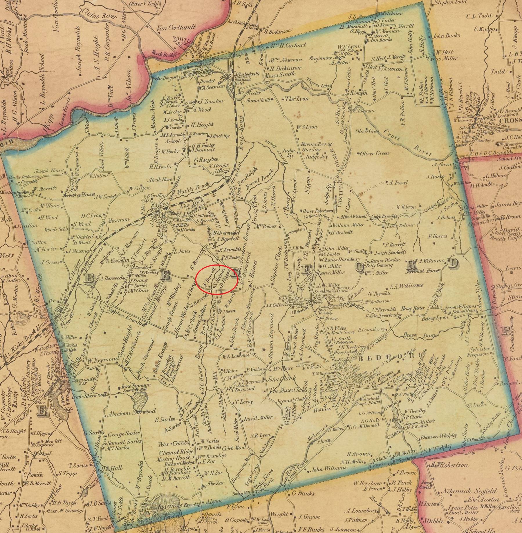
Map of Bedford in 1851 from the map of Westchester County, New York by Sidney and Neff [12]. The area where Abigail Waterbury Gray ran a tavern of Broad Brook Road is inside the red circle.
After we left the Bedford Town Historian’s office, we drove down Broad Brook Road to see the area where Abigail Waterbury Gray ran a tavern. The road was unpaved, and the area included many upscale homes. According to the director of the Bedford Historical Society, the residents don’t want their road paved in an effort to discourage outsiders. Clearly, nothing remained from the time Abigail and Samuel lived in the area.
Buxton Cemetery, where Samuel and Abigail are buried, is not far from Broad Brook Road. The map of the cemetery below was provided by the Bedford Town Historian. The location of Abigail’s grave is marked on the map. The photo below shows Abigail’s gravestone on the lower left side.
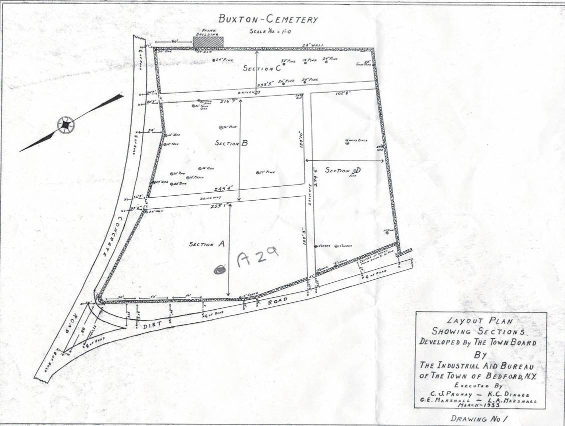
Map of Buxton Cemetery showing the location of Abigail Waterbury Gray Barrett’s grave, A29.
Brien, Barry, and Bob at the gravesite of Abigail Waterbury Gray Barrett. She was one of our fourth great grandmothers.
I could be mistaken, but it seems like our group selfie work improved greatly over the course of our trip.
After Buxton Cemetery, we went to the Town of Bedford to do more research at the Bedford Free Library and to meet with the director of the Bedford Historical Society. As the tavern run by Abigail dated back to the Revolutionary War time, I had hoped that someone from the society had taken a photograph of the tavern before it was torn down to make way for the Interstate Highway, but I was disappointed. We examined several old maps held by the society, but none provided more information on the property. The director suggested we visit the Bedford Oak tree. The society’s web page says the tree is “At the corner of the Hook Road and the old Bedford Road (now Cantitoe Street) stands a majestic and venerable white oak tree, "Quercus alba". It is estimated to be over 500 years old, its girth is more than 30 feet, and the spread of its branches is 120 feet from tip to tip. From the days when Bedford was Indian Territory, through the Revolutionary War and to the present, this noble tree has seen much history.” Given the tree’s age and its location between the Town of Bedford and Broad Brook Road, it is likely that our ancestors passed by this tree many times during their lives. The short side trip to see the Bedford Oak was well worth the time as demonstrated by the photograph below.
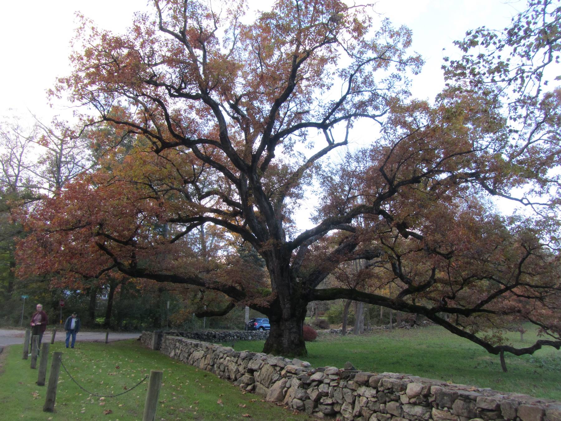
Barry and Brien by the Bedford Oak tree. The tree is estimated to be over 500 years old, making it very likely to have been seen by our ancestors who lived in Bedford during the time of the Revolutionary War.
Our final stop on the trip was at the Westchester County Archives located in Elmsford, New York. Our research uncovered two more genealogical records on the Grays. I have posted the genealogy documents I have for the Grays and related families under my family history page. My brother Barry compiled a bibliography of the reference documents we found during the trip which I have also posted with this page. I asked a staff member at the archives if they would have any photographs of tavern run by Abigail. This time my query produced the aerial photograph shown below. It was taken in 1925. The dashed red line is the approximate location of the northbound lanes of the Interstate Highway. The area outlined in blue is believed to be the property owned by Abigail Waterbury Gray at the time she married Samuel Barrett. The left edge of the blue box is Broad Creek and the bottom edge is Broad Creek Road, making it to the north of the road and east of the creek per the description of the property given by Katharine Barrett Kelly. The southbound lanes of the Interstate Highway run to the left of Broad Creek.
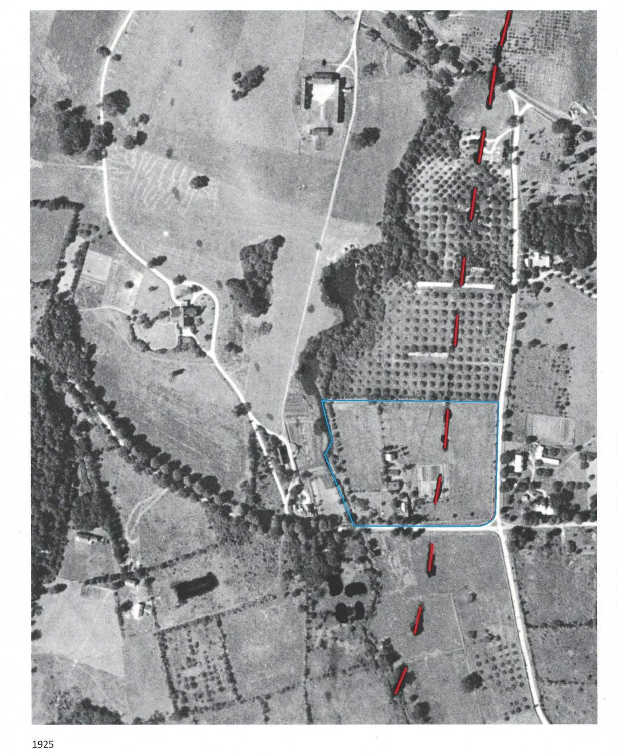
Aerial map from 1925 showing the location of the property owned by Abigail Waterbury Gray outlined in blue and the approximate path of the northbound lanes of the Interstate Highway. Broad Creek runs along the left edge of the blue box and Broad Creek Road runs along the bottom of the blue box.
We were also given the map below which is from 1930 showing the same area. This map indicates the property, consisting of nine acres, was owned by Betsy P. Huffman and was called Fair Meadow Farm. The map shows four buildings which is consistent with the aerial view above.
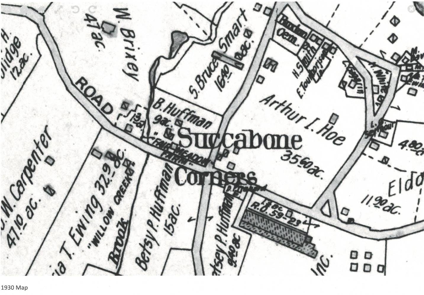
Map from 1930 showing the same area as the aerial map from 1925.
Conclusions
Our third family history trip was extremely enjoyable and very productive. The local history and genealogical documents we found along the way provided a great deal of new information about our family. I am still in the process of updating the family genealogy pages with the new information. A bibliography of the documents we found of interest during our trip is located here. A collection of genealogies for the Gray and related families we found during our trip is posted here.
We visited several areas in Connecticut and Bedford, New York that were originally owned by members of the Gray family. None of the original buildings on these properties are in existence today. It was interesting to see these places to get a sense of what their life was like. It is worth noting that the property in the Town of Fairfield, the Bankside Farm in what is now Westport, and tavern on Broad Brook Road in Bedford, New York are all very expensive and exclusive properties today. In each case, the Grays were among the earliest settlers which may account for their ability to acquire what today is prime property.
For the most part, our cemetery visits were unproductive, but we did find the graves of two important ancestors. Henry Gray Jr, who was born in 1653 and died in 1731, was a sixth grandfather. Abigail Waterbury Gray Barrett, who was born in 1743 and died in 1805, was a fourth great grandmother.
Although none of our research provided the picture of the tavern run by Abigail Waterbury Gray I was hoping to find, it did identify some new lines of research that may prove fruitful. The names of the owners of the property were found on maps dated 1851 and 1930. Research on these owners may provide additional information about the property.
References
2. Schenck, Elizabeth Hubbell Godfrey, The History of Fairfield, Fairfield County, Connecticut, from the Settlement of the Town in 1639 to 1818: 1639-1700 Volume 1889, page 65.
3. Coldham, Peter Wilson, “The Complete Book of Emigrants, 1607-1660,” Baltimore: Genealogical Pub. Co., 1987. p.204-205.
4. Private communication, Susan Graham, Fairfield Museum and History Center, 21 November 2018.
5. Jennings, George Penfield, “Greens Farms, Connecticut, the old West parish of Fairfield”, The Congregational Society of Greens Farms, 1933.
6. Raymond, M.D., Gray Genealogy, Tarrytown, NY, 1887, Pages 198-9.
7. Jacobus, Donald Lines, History and genealogy of the families of old Fairfield, Volume I, Tuttle, Morehouse & Taylor Co., New Haven, Connecticut, Page 232.
8. Public Records of the Colony of Connecticut Volume 2, Page 239.
9. Judd, Peter H., Four American Ancestries: White, Griggs, Cowles, Judd, Including Haring, Phelps, Denison, Clark, Foote, Coley, Haight, Ayers, and Related Families, Volume I, 2008.
10. Bedford Historical Records, Volume IX, Bedford Genealogy Descendants of the Original Twenty-Two Settlers, Published by the Town of Bedford, 1978, Pages 174 through 182.
11. Duncombe, F R, et. al., Katonah, Published by the Katonah Village Improvement Society, 1961, Pages 365 through 369.
12. Lionel Pincus and Princess Firyal Map Division, The New York Public Library. "Map of West Chester County, New York" The New York Public Library Digital Collections. 1851. http://digitalcollections.nypl.org/items/91f41b70-d53d-0130-2826-58d385a7bbd0.
Home (Search) | Bob Gray Consulting | Family History | Genealogy | Oswego Maps
Copyright 2019, Robert F Gray